Constructed over 55 years ago, the earthen barrier surrounding the large reservoir that contains the water supply for the massive Niagara Power Project hydroelectric generating plant at Lewiston, NY, may be experiencing worrying signs of deterioration, according to an authority in radioactive hazards and disaster preparedness, which he shared, along with his analysis with the Reporter.
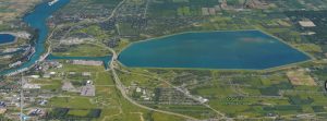
The Lewiston Reservoir (background) contains billions of gallons of water. The federal government recently ordered NYPA to update emergency flooding plans in light of possible leaking. The village of Lewiston, the town of Niagara and the Tuscarora Reservation are located next door to the huge, elevated reservoir.
The facts are these:
A letter dated November 27, 2015, from Gerald L. Cross, Regional Engineer for the Federal Energy Regulatory Commission (FERC) division of Dam Safety and Inspections, to New York Power Authority (NYPA) engineer Robert J. Knowlton, reveals that during a June, 2015 annual dam safety inspection, a sinkhole was discovered in near proximity to the Lewiston Reservoir dike.
In response to the FERC write-up, Knowlton, who is based at NYPA headquarters at White Plains, NY, initiated an investigation, and subsequently “indicated that the sinkhole was due to a swale drainage issue and not related to the reservoir.”
“You (Knowlton) have stated that the sinkhole has been repaired and provided photo documentation,” continues the letter.
Dictionary.com defines swale as “a low place in a tract of land, usually moister and often having ranker vegetation than the adjacent higher land.” Swales commonly occur on lawns and golf courses, particularly after a heavy rain. A sinkhole, on the other hand, is defined as “a cavity in the ground caused by water erosion and providing a route for surface water to disappear underground.” While Florida is infamous for sinkholes due to erosion of subsurface limestone, a sinkhole at the base of an earthen dam holding back a reservoir may be a sign of a breaching of the embankment and a harbinger of total collapse.
The reclassification to swale, of what was initially identified as a sinkhole by a professional engineer during a formal annual inspection of the base of the Lewiston Reservoir, may be cause for public concern, since FERC goes on to advise Knowlton to “continue to monitor this area… (and if) you note any adverse changes, you are to notify this office immediately.”
History is replete with cases of catastrophic earthen dam failures. Nearby, a 1974 subsurface breach of a bank of the Erie Canal caused widespread flooding of several square miles of a rural area outside Rochester, NY. No lives were lost.
A remarkable Youtube video entitled “Teton Dam Disaster” documents how slipshod planning and construction by the US Bureau of Land Reclamation culminated in gradual erosion of an earthen barrier that held back the Teton River. In the early morning hours of June 5, 1976, a small leak appeared midway down the dam’s face, and four hours later the entire embankment gave way, flooding the Snake River plain, killing 11 people and causing total damages exceeding $2 billion.
There was also the great Johnstown Flood of 1889. 20 million tons of water from a man-made reservoir known as Lake Conemaugh inundated the small city of Johnstown, Pennsylvania, when its earthen dam failed after several days of rainfall, killing 2,209 people.
According to a NYPA Preliminary Draft Environmental Assessment (PDEA) document prepared a decade ago as part of its 50-year relicensing application, “… the 1,900 acre Lewiston Reservoir has a gross storage capacity of 74,250 acre-feet or 24 billion gallons.”
24 billion gallons of water weighs a little over 100 million tons, so the amount of water in the Lewiston Reservoir is approximately five times greater than that involved in the great Johnstown Flood, the worst flooding disaster in US history.
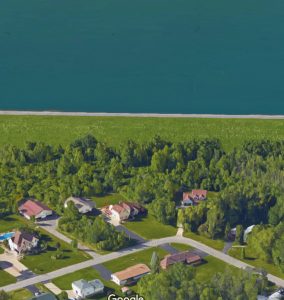
As one can see from the picture, the reservoir is elevated and stores water above the houses below it. An inundation plan exists and the Reporter will attempt to obtain it.
A second letter sent just two months ago from FERC to NYPA, recently obtained by us, clearly indicates that what FERC had persisted in calling a “sinkhole”, caused a good deal of behind-the-scenes activity by the two agencies, activity which only now is coming to light.
In a letter dated June 30, 2016, FERC engineer John Spain wrote to Knowlton, “By letter dated September 16, 2015, you submitted a dam breach analysis that was prepared by your consultant… The analysis was conducted to update the Emergency Action Plan (EAP) and develop inundation mapping… Within 30 days from the date of this letter please provide your plan and schedule to update the EAP.”
To summarize, a suspected sinkhole discovered in June, 2015 was downgraded by NYPA to swale status, but still considered to be significant enough to trigger an update to the Niagara Power Project Emergency Action Plan and formulation of an inundation (“flood”) plan, neither of which was referenced in the original November, 2015 letter.
The “inundation plan” referred to in the letters is not available on-line.
The FERC web site responds as follows when one attempts to access the Niagara Power Project Emergency Action Plan: “You don’t have permission to access this document. This document is Critical Energy Infrastructure Information (CEII). The public may file a CEII request under 18 C.F.R. 388.113.”


